DATE
Loading...
TIME
Loading...
About Us

The Philippine Space Agency (PhilSA) has released satellite-based assessments showing damaged structures, shoreline changes, and the gradual return of nighttime lights following the magnitude 7.8 earthquake that struck southern Mindanao on June 8.
Using space-based observations, PhilSA said it is analyzing the extent of the earthquake’s impact to help government agencies monitor affected communities and prioritize disaster response efforts.
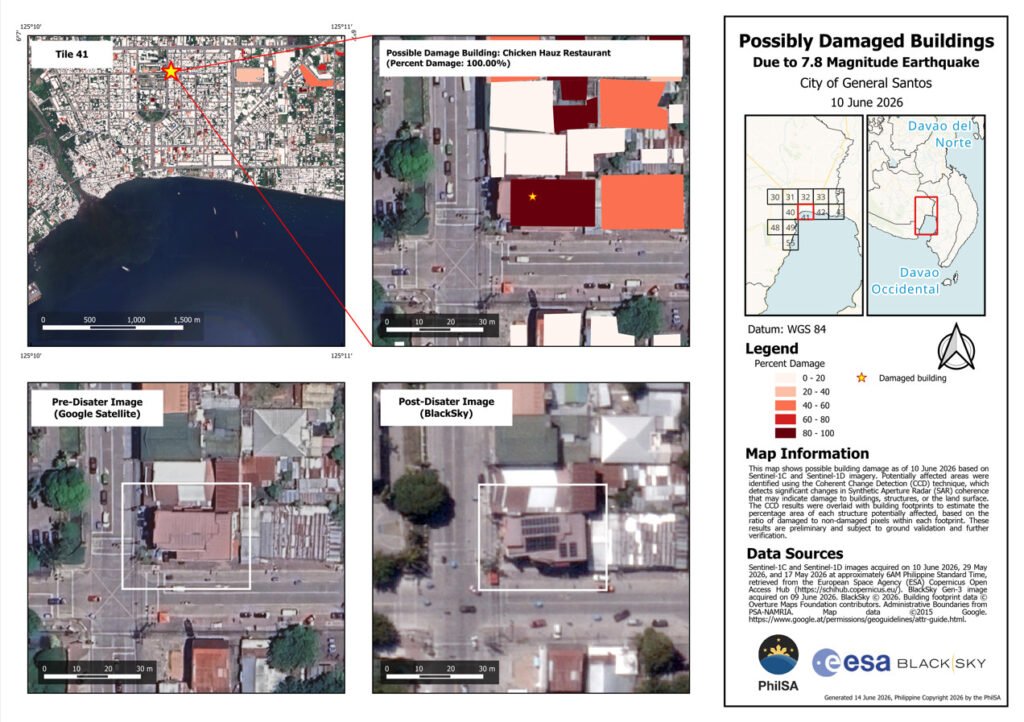
One of the agency’s latest products includes damage assessment maps of General Santos City, where areas marked in red indicate possible changes to buildings, structures, or the land surface as of June 10.
The analysis was generated through change detection using Synthetic Aperture Radar (SAR) images captured by the European Space Agency’s Sentinel-1C and Sentinel-1D satellites, allowing experts to identify areas that may have sustained significant damage even under cloudy conditions.
PhilSA also utilized post-event very high resolution (VHR) satellite imagery to capture individual buildings that appeared to have suffered structural damage.
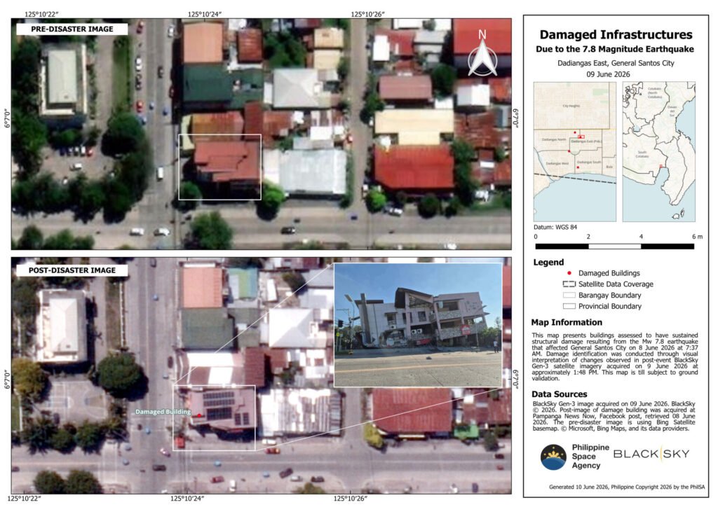
By overlaying the SAR change detection results with the high-resolution images, the agency produced detailed maps highlighting buildings that likely sustained the most damage. PhilSA noted that these findings remain subject to ground validation.
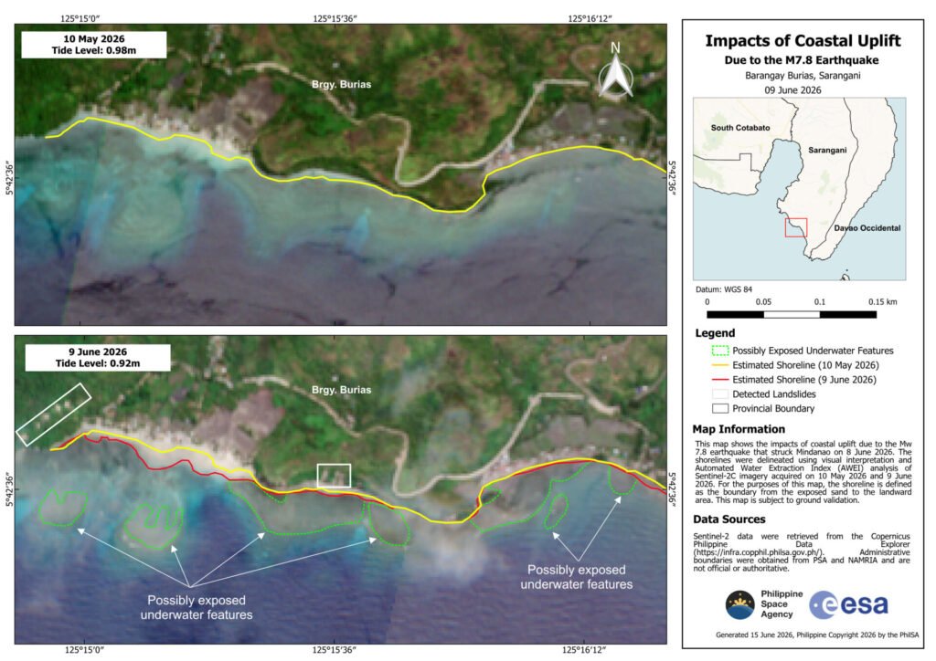
Beyond structural assessments, satellite imagery also revealed coastal uplift in parts of Sarangani province.
Maps generated by PhilSA showed noticeable shoreline shifts in Barangays Burias and Pangyan, where portions of the coastline moved after the earthquake. In the analysis, pre-earthquake shorelines were marked in yellow, while post-earthquake shorelines were marked in red. Green areas indicate features that may have previously been underwater but are now exposed.
The shoreline analysis combined visual interpretation with the Automated Water Extraction Index (AWEI) using Sentinel-2C satellite images acquired before and after the earthquake. PhilSA emphasized that these observations also require validation on the ground.
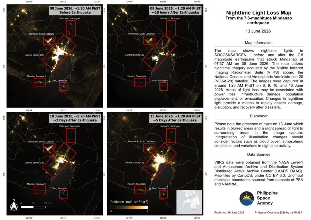
The agency has likewise been monitoring nighttime lights in affected areas, using satellite imagery to assess disruption and recovery.
According to PhilSA, changes in nighttime illumination provide a rapid way to identify areas experiencing power outages, infrastructure damage, or population displacement. Recent observations indicate the gradual return of nighttime lights in parts of the affected region, serving as a possible indicator of ongoing restoration and recovery efforts.
PhilSA said its satellite-based analyses provide wide-area situational awareness that supports the National Disaster Risk Reduction and Management Council (NDRRMC) in prioritizing response operations.
By making space-derived information accessible to government agencies and stakeholders, the agency said satellite technology plays an increasingly important role in disaster monitoring, damage assessment, and evidence-based decision-making across the country.